
Upper Boston Post Road #6 (UPBR #6) Alternate Route Entry #1

“About 10 Mr. Gerry called me, and we rode to Framingham, where we dined. Coll. Buckminster after Dinner shewed us, the Train of Artillery brought down from Ticonderoga, by Coll. Knox.”
Diary of John Adams, Thursday, January 25, 1776
Immediately upon entering Wayland I reach an important junction and I am confronted with a dilemma. Wait, this feels like Groundhog Day. When I finished the previous entry I was standing on the corner of Old County Road and Boston Post Road in Sudbury more than four miles further along the Upper Boston Post Road. Now I am right back where I started the last entry, standing at the junction of Boston Post Road and Old Connecticut Path just over the border from Weston in the town of Wayland.
The reason for this deja vu is that I am about to take a different road for twenty miles or so from the road I have been following, which I wrote about in the previous entry. I don’t really want to do this walk, leaving the Upper Boston Post Road to follow the so-called Old Connecticut Path to Framingham just as I am gathering a little momentum. I am not convinced there was an Old Connecticut Path, the contemporary name of the road that heads southwest from the junction with Boston Post Road on the border between Wayland and Weston. I am being diverted from my main focus, following the Post Road.
However….John Adams did it. The British spies Captain William Browne and Ensign Henry DeBerniere did it. Colonel Henry Knox probably did it. It is one of the most frequently cited examples of an early path taken by English explorers wandering west from Boston.1A.S. Hudson, for example, in The Annals of Sudbury, Wayland, and Maynard (1891) says of Old Connecticut Path “A noted Indian trail, at the time of the English occupation passed through the southeasterly part of the territory. This was part of an ancient way to Connecticut.” see p. 37. Incidentally, Plate 14 (Wayland) of the 1908 Middlesex County Atlas (available at Digital Commonwealth) does not call the road anything and Plate 5 (Framingham) calls it Cochituate Street. It is clear the name was changed to Old Connecticut Path at a later date. I need to know why so many of the first-hand travel narratives I have used for this project took an alternate route to Worcester through Framingham. Thus, I turn left away from the Boston Post Road for a diversionary walk to Framingham along Old Connecticut Path.
I am not following the trail because I believe it is the “ancient way to Connecticut.” I am deeply skeptical of this idea, despite the presence of a stone marker on the traffic island in the triangle between Boston Post Road and Old Connecticut Path directly in front of the Coach Grill in Wayland. This marker, placed here by the Daughters of the American Revolution in 1969, states “Old Connecticut Path, an ancient Indian trail and the route of Rev. Thomas Hooker’s flock to Connecticut in the year 1636.”2I think the marker has been slightly moved as there is a photograph from 2009 which shows it facing the traffic coming from Weston directly; nowadays it rests below some cherry trees on the south side of the island facing Old Connecticut Path. I have yet to find any real evidence for this statement and my initial research on this “Ancient Trail” has turned up little in the way of an actual route with defined parameters. I don’t doubt that it is an old road as it appears in the records of Sudbury in the 1640s as “the way from Watertown to Dunster’s farm,”3Wayland Historical Trails, p. 13. but I have read too many local histories that clearly conflate the Post Road, Old Connecticut Path and another old road called the Bay Path, the details are often contradictory and there are scant primary sources attesting to the existence of the road; much of it appears to be wishful thinking by local historians that was picked up uncritically by later historians. It could certainly have been an old road to Connecticut but there is just too much evidence that the Post Road was the principal route followed by people traveling west to the Connecticut River Valley, which is the original seventeenth-century meaning of the word “Connecticut.”
Regardless of the veracity or plausibility of the origin story of this particular road, it is a fact that it was used as an alternative route to Worcester by at least one person: John Adams. On a trip to Connecticut which Adams described in an early diary entry from May 30, 1771, he followed the traditional route of the Post Road through Watertown, Sudbury, and Marlborough to Worcester on his way to Connecticut, returning along the same road two weeks later; in later years he frequently took the left turn here at the Coach Grill in Wayland and continued to Worcester and beyond via Framingham instead of continuing straight along the Post Road through Sudbury and Marlborough.4Adams Diary Vol. II p. 17 and p. 35.
For example on August 10, 1774 Adams, along with his cousin Samuel Adams, Thomas Cushing, and Robert Treat Paine, set off for Philadelphia as representatives for Massachusetts at the First Continental Congress. After stopping at Coolidge’s Tavern in Watertown 5I discuss this in my article Watertown: Circling The Square for a farewell meal, they set out on the road, and as Adams concisely puts it, summarizing the entire trip from Watertown “I lodged at Colonel Buck’s”6Adams Diary Vol. II p.97 This phrase, when I first interpreted it, caused me some anxiety. “Bucks” is a reference to a tavern run by Colonel Joseph Buckminster, a notable Framingham citizen. It is not on the Boston Post Road; thus I knew early on that I would have to figure out what route Adams and his companions followed and why.
Adams “Lodged at Coll. Buckminsters of Framingham” on November 8, 1774 on his return trip to Boston, and definitely came up Old Connecticut Path because the next morning he “breakfasted at Reeves” which is the principal site of interest along the 1.7 mile walk from the Coach Grill to the junction of Old Connecticut Path and Cochituate Road in Wayland. He recorded a bill of 5 shillings at “Buckminster’s in Framingham” among a list of expenses for his next trip to Philadelphia in late 1775, although he returned to Boston via the Lower Post Road through Providence on that trip.
The most well-known of Adams’ visits to Buckminster’s is recorded in his diary entry for Thursday, January 25, 1776: “About 10 Mr. Gerry called me, and we rode to Framingham, where we dined. Coll. Buckminster after Dinner shewed us, the Train of Artillery brought down from Ticonderoga, by Coll. Knox.” This entry also alerted me for the first time to the fact that Colonel Henry Knox, whose route to Cambridge with the aforementioned “Train of Artillery” is commemorated with markers along the Post Road which I have dutifully listed as I made my way west, also did not follow the Boston Post Road at this point, since his artillery were situated in Framingham at least as of January 25, 1776.

To make matters even more complicated, another narrative I have used to guide me along the Post Road, the adventures of two spies Captain William Browne and Ensign Henry DeBerniere in the winter of 1775, also follow the diversion to Framingham. On their initial foray west from the Golden Ball Tavern in Weston, the two men “proceeded to Buckminster’s,” and continued on to Worcester as we shall see. DeBerniere explicitly states that this was not the main road to Worcester as they later ventured out a second time from the Golden Ball Tavern, only this time “we were resolved to go the Sudbury road, (which was the main road that led to Worcester) and go as far as the thirty-seven mile-stone, where we had left the main road and taken the Framingham road.”7 General Gage’s Instructions, p. 10 DeBerniere is specifically referring to the fact that, having taken the Framingham road out to Worcester on the first expedition, they had intended taking the main road, the Post Road, back to Weston. However, they ran into a suspicious character who rode on ahead of them and, fearing they were about to be ambushed on the road ahead, decided instead to return by way of the “Framingham road.” Thus, to complete their mission, they felt it necessary to follow the “main” or Post Road through Sudbury and Marlborough as far as the place they turned off, at milestone 37. Fortunately there are a lot of clues in this narrative about the roads which will prove useful in trying to sort out the route of the alternative road to Worcester.
*****
Compared to the very busy Boston Post Road, which is also US Route 20 in much of Weston and Wayland, the first 1.7 miles along Old Connecticut Path is bucolic. Low stones walls line the road behind which are elegant houses set back on large lots interspersed with wooded area and the fields of Mainstone Farm, which unfurl away from the road up the slopes of the hills along the south side of the road. However, it is a difficult road to walk as there is no sidewalk and little shoulder, steep embankments frequently drop to the edge of the road, and there is more traffic than one might expect along a very narrow road, almost a lane. This walk is not fun, and would be virtually impossible in the snow but fortunately winter seems to have skipped this year, so I keep a wary eye open as I make my way. Incidentally, since at least 1713, when Robert Cutting established a farm which stayed in the family until the 1850s, there has been a farm along this road.8Evelyn Wolfson and Dick Hoyt, Wayland A-Z: A Dictionary of Now and Then, (Saline, MI: McNaughton & Gunn, 2004.),pp. 62-3. Evidence that Knox and the train of artillery passed this way is reported to be in a Cutting family journal which reportedly describes that “they heard the caravan coming and invited the men up the hill for a meal.”9Wayland A-Z, p. 108.

The highlight of this section of Old Connecticut Path is the house that once served as Reeves Tavern at 126 Old Connecticut Path, the tavern where Adams had breakfast. Part of the original building is thought to date to 1715, when a house was built by Matthew Hasey.10Wayland Historical Society Tours, p. 53. See also Helen Fitch Emery, The Puritan Village Evolves: A History of Wayland, Massachusetts,(Canaan, NH: Phoenix Publishing, 1981.), p. 93. Jacob Reeves, a prominent citizen of Sudbury and later East Sudbury in 1780 when the town now called Wayland split from what is today Sudbury, apparently arrived in the early 1760s, but had opened the tavern by 1764.11Wayland Historical Tours, pp. 53-54.
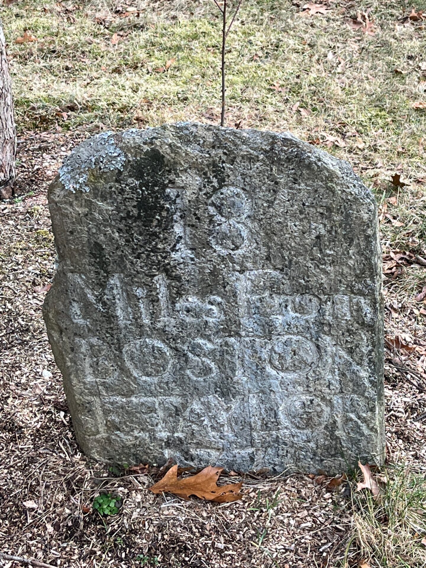
Along the stone wall lining the road in front of the house is an old milestone which is difficult to read, but clearly says “BOS” meaning Boston. Evelyn Wolfson and Dick Hoyt in Wayland A-Z, claim the milestone “gives the number of miles as seventeen to the Boston marker near Fanueil Hall”12Wayland A-Z, p. 129 I can’t see the number so I have to take their word for it. However, the actual origin point for the milestones around Boston was not the Boston Stone as they suggest, but rather the Old State House, a topic I discussed in a previous entry. The presence of the stone does suggest that the road was likely a well-traveled route. The mile 17 is somewhat puzzling though, as the site of Wilson’s tavern in Weston is 16 miles distant from Boston and the Weston/Wayland border is 17.4 miles distant from Boston. Reeves Tavern is 1.2 miles from the border, indicating the tavern should be at least 18 to 19 miles distant from the Old State House, even accounting for the possibility that the measurement is via Harvard Square and Charlestown, which was a slightly shorter route west from Boston in the eighteenth century.13See my entry Exit Timing for a discussion of different routes west out of Boston over time

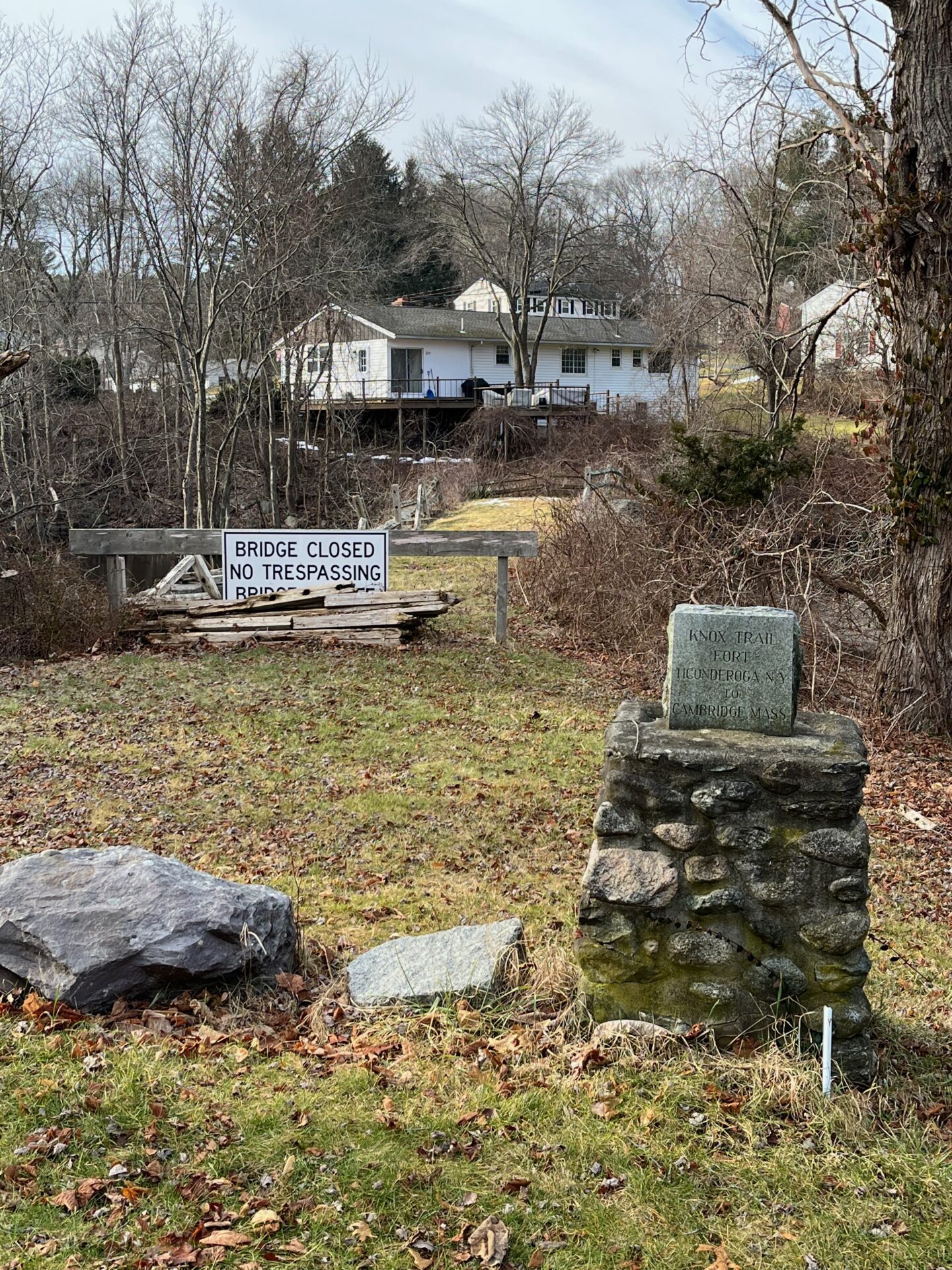
A few minutes walk from Reeves Tavern brings me to the busy intersection of Old Connecticut Path and Cochituate Road, which was formerly referred to as “Five Paths,” although today only four remain.14Wayland A-Z, p. 74. Cochituate Road (Route 27) is the direct route from Wayland center to the village of Cochituate in South Wayland and Natick. Old Connecticut Path continues southwest across Cochituate Road for 1.9 more miles to the border with Framingham near the northern end of Lake Cochituate. There is another stone marker on the peninsula of land jutting into the intersection on the south side. This particular monument is another of the markers commemorating the journey of Colonel Henry Knox and his train of artillery from Fort Ticonderoga to Boston in the winter of 1776, indicating that Knox passed this way and not along the Boston Post Road through Sudbury.
A local resident named Steven Glovsky took an interest in this marker that he reckons he has passed at least 30,000 times and eventually followed the route of Knox all the way to Fort Ticonderoga, located between Lake George and Lake Champlain in upstate New York. He also compiled a helpful list of the location of all the markers. His list is immediately useful as it indicates that there is a marker in the town of Framingham, near Buckminster’s Tavern, and also in Southborough, the town immediately west of Framingham, which hints at a possible route west from Framingham to Worcester, which I will return to later. In a recent lecture at the Sudbury Historical Society, Glovsky provides interesting anecdotes about this particular marker as well as some speculation about the potential route of Knox’s train of artillery through Wayland and Framingham. This particular marker was originally placed on the north side of the intersection but was relocated when the retaining wall was built along the edge of the steep hill looming over the eastern edge of the intersection.
Glovsky’s entertaining lecture recounts the origins of the markers and the establishment of the “Knox Trail” in the years 1925-1927. The most interesting information relating to my project is that, although a committee was established to reconstruct the route of Knox and his train of artillery, it is not entirely clear how they came to their conclusions, especially regarding the area of Wayland and Sudbury. As Adams has made clear, the artillery was definitely in Framingham on January 25, 1776. The route from Framingham to Dorchester Heights in South Boston or to Cambridge is not clear at least in Framingham, Wayland, and Sudbury. As I mentioned above, there is some evidence he followed Old Connecticut Path up to Boston Post Road, passing Mainstone farm, and so it seems likely Knox passed this way en route. As we shall see shortly, the story gets more complicated a little further down Old Connecticut Path.
Five minutes walk south along Old Connecticut Path from the Knox marker at the intersection brings me to Henry Knox Road. This dirt road is likely the fifth of the “Five Paths” and apparently once went all the way up to Wayland Center. Wayland strangely seems to have lots of roads that have disappeared. The implication of the road name is that Knox took his cannon along the now forlorn path, but this seems optimistic.
After five more minutes walk I pass a large stone with a plaque dedicated to Edmund Rice, an early settler of Sudbury whose house was nearby and who eventually settled the town of Marlborough through which the Upper Boston Post Road passes after traversing Sudbury. At 252 Old Connecticut Path is a lovely red house, the Hopestill Bent house, built about 1710, which was run as a tavern, but by 1775, Lieutenant Whitney was living in this farmhouse at 252 Old Connecticut Path.15Wayland Historical Tours, p. 46.

Just beyond the house, across the street and directly opposite the entrance to Wayland High School is another milestone, which is slightly back from the street and more neatly carved than usual, reads 18 Miles from Boston. T. Taylor, 1771. Apparently the road was straightened at some point and the marker was moved across the street to this location. The distance from the putative 17-mile stone at 126 Old Connecticut Path is 1.3 miles, which makes these milestones even more problematic than previously mentioned, as the actual distance to Boston along the old road is now close to 20 miles.
A further 7 minutes walk beyond the 18-mile stone is Stonebridge Road and another dilemma. According to Glovsky, the main speaker at the dedication of the Knox marker in Wayland on Friday November 4, 1927 was John H. Temple, who gave a speech entitled “How the Artillery was Brought.” Temple was the son of local historian Josiah Temple, who wrote a History of Framingham in 1887, and the younger Temple was the Chairman of the Framingham Bicentennial Commission in 1900. Temple argued that the artillery train came through the spot where the dedication speech was given at Old Connecticut Path and Cochituate Street in Wayland not by following Old Connecticut Path through Framingham, but rather by following Edmand Road to Potter Road in Framingham and Stonebridge Road in Wayland, crossing the Sudbury River that marks the boundary between Framingham and Wayland at the “stone” bridge, the argument being wooden bridges could not have handled the load so they must have traveled over a bridge made of stone. Glovsky points out that the “stone” in “Stone’s Bridge” was actually the name of a local family and that the stone bridge that is there now was a wooden bridge before the mid-nineteenth century. Subsequent narratives, however, always mention the bridge as the route of the artillery and even refer to the bridge as a crucial part of the trail west of Wayland. Wayland A-Z even states that it was part of “a highway that went from Watertown to Brookfield,” and that not only did Knox cross it, but so to did the spies Browne and DeBerniere.16Wayland A-Z, p. 13.
Thus it seems that the diversion from the Post Road, Old Connecticut Path, has now brought me to another diversion, Stonebridge Road; a diversion from my diversion, if you will. If I was skeptical of the Old Connecticut Path story, at least there are old taverns and milestones along the way to provide some evidence of the historical importance of the road. More importantly, the official map of Wayland from 1794 produced by Mathias Mosman, shows the “road from New Bridge” but labels Old Connecticut Path “County Road from Framingham” which continues as “the Road threw (sic) Framingham.” Thus what is now called Old Connecticut Path was clearly the main road through this part of Wayland on his map. The map of Framingham of 1794, by Lawson Buckminster does not show Potter Road at all, but does show Old Connecticut Path as a “County Road” that crosses Framingham, directly passing “Buckminster’s Tavern,” which is prominently labeled on the map. The 1832 map of Framingham by Nixon and Clayes shows the “New Bridge” and the “Road to East Sudbury”, Potter Road today, but it also shows Old Connecticut Path as the “Great Road to East Sudbury,” implying it is the more important road.

Old Connecticut Path, even if it is not the old road to Connecticut, was certainly the main road through this area in the eighteenth century as is indicated on the earliest officially surveyed maps of the towns for the state of Massachusetts. The idea that Browne and DeBerniere followed Stonebridge Road to get to Buckminster’s tavern, when the road they had followed from Weston led directly to Buckminster’s tavern, had milestones conveniently placed along it, including the 23-mile stone directly in front of the tavern, seems implausible. There is no mention of the bridge in their diary; all they say of the nine-mile trip between the Golden Ball Tavern and Buckminster Tavern is that it was “very rainy and a kind of frost” and “we met nothing extraordinary on the road; we passed some time in sketching a pass that lay in our road, and of consequence were very dirty and wet on our arrival”17General Gage’s Instructions Narrative, p. 7. They did not finish their map in this area beyond drawing a “Road to Framingham” which peters out on the map, while the “Road to Sudbury”clearly shows a bridge over the Sudbury River, the town bridge discussed in the previous entry on Wayland.
Of course, I head down Stonebridge Road anyway to see for myself. As was the case with the Town Bridge between Wayland and Sudbury, the old bridge was damaged in a flood in the 1950s and a new bridge was built a few yards south of the old bridge along a slightly straighter road. However there is an Old Stonebridge Road which I follow a few yards to reach the remains of the nineteenth-century bridge made of stone called Stone’s Bridge after the local Stone family. It is currently closed to any traffic but is photogenic. There is also a marker at the site indicating Knox’s “visit” the story of which Steven Glovsky humorously recounts in his lecture on the Knox markers in Wayland.
Returning to Old Connecticut Path I continue along what was the main road to Framingham in the nineteenth century and continues to be today. Bucolic and idyllic as the area around Stonebridge Road is, the evidence indicates the true path through this area is the road I have been following. Ten minutes more walk along the road brings me to the junction with Plain Road, another old road that leads to Natick. The 19-mile stone that sits in Wayland center apparently once graced the northeast corner of this intersection. At least the distance is one mile from the 18-mile stone opposite Wayland High School. Just beyond Plain Street is the northern shore of large Lake Cochituate and the border with Framingham. The diversion in Wayland along Old Connecticut Path is a walk of 3.6 miles total, not including the diversion from my diversion along Stonebridge Road. In addition to the 4.2 miles I walked along the route of the Upper Boston Post Road, I wandered other roads in the area as well, but this will quickly become a second Wayland A-Z if I don’t continue on, so after walking many miles through the town learning about the history of the town through its roads, it is time to leave the local history of Wayland to the local historians of Wayland and bid farewell to Wayland.
*****

As with the entries I have written thus far, I will continue the pattern of containing my walks to the limits of a single town for each entry. Framingham is the next town through which this alternate road to Worcester passes, after which the road passes through the towns of Southborough and Westborough, before rejoining the main road, Boston Post Road, in the town Northborough. I have included three maps below which show the route. The first map is my own Google Map of the route of Boston Post Road and the “Alternate Route” via Old Conncecticut Path through Framingham, what I have termed the “Framingham Diversion.” The second map is an annotated version of Osgood Carleton’s Official State Map of Massachusetts, approved by the legislature in 1801 (his first map of 1798 was rejected). Onto this map, which was stitched together from all the official maps of each town, including Mosman’s map of Wayland and Buckminster’s map of Framingham, I have mapped out the roads I believe, based on the evidence I have accumulated, that were traveled by John Adams and by Ensign DeBerniere and Captain Brown in the 1770s. I will discuss the possible route of Henry Knox in a future entry, as it is slightly more complicated. The last map is a more detailed map of Wayland. The green line represents the route of the walk in this essay.
*****

Total distance traveled in this entry: 3.6 miles
Total distance covered on the Framingham Diversion Route: 3.6 miles
Total distance covered for all the walks described in Boston Rambles: 65.1 miles
[…] Since everyone else seemed to have gone there I might as well follow in their footsteps. In the previous entry I described the route from the point at which it deviates from the Post Road near the border […]
Permalink[…] Yet the image of a younger version of myself bursting with ambition and camaraderie is uppermost in my thoughts as I make my way down the gravel pathway leading to the very real Wayside Inn and the meadows across from the Inn come into view. I arrive here as I continue my walk along the Upper Boston Post Road from Boston to Springfield, the subject of most of the recent entries in this project. In this entry, I walk across the town of Sudbury, Massachusetts from Wayland, where I left this road for a short while and wrote about an alternative road for a few entries. […]
Permalink[…] Mention: Milestones, Wayland, Framingham, Southborough, […]
Permalink