
The Path Of Destruction
Upper Boston Post Road Entry #14 (UBPR #14)
Matthew 7:13-14, King James Bible, from the Sermon on the Mount
*****
A walk along the Upper Boston Post Road through Worcester, Massachusetts, the second most populous city in New England, traverses an arc of 7.5 miles in length from northeast to southwest that passes through the center of the city along Main Street. A typical entry in this project describes a single walk along the road through the town in which it passes but the size and importance of the city of Worcester obliges me to depart from the normal pattern of these entries and instead break the walk through Worcester into three sections. This first entry covers the walk from the Shrewsbury border to the site of the original Worcester County Courthouse on the north end of Main Street, the place from which distances in the county were traditionally measured. The first walk, a distance of 3.2 miles, is almost entirely along Lincoln Street. The second entry will follow Main Street through the center of the city from the Worcester County Courthouse to City Hall, a distance of about 0.6 miles, while a third entry will follow Main Street southwest from City Hall to the border with the neighboring town of Leicester, a distance just under 3.7 miles.
*****
Seeking the Narrow Way
Not every mile of the old road from Boston to Worcester is exciting, scenic, and lined with history. Occasionally the road passes through less interesting and, at times, unpleasant areas devoid of evidence that the road is a centuries-old trail across Massachusetts, usually because the area has succumbed to commercial development, sometimes because the road has been expanded or straightened or because an interstate highway has been built over or near the road, or simply because the road passes through a poor or neglected neighborhood (or worse, poor but not neglected; see countless housing projects foisted upon unwilling residents over the decades since the 1945). The route of the Upper Boston Post Road into Worcester, from the Shrewsbury border to the site of the original Worcester County Courthouse on Main Street, is the first unfortunate stretch of road on this project where ALL of the above circumstances apply, on top of which the road in this area also had the misfortune of being hit by the largest tornado in the recorded history of New England. Nevertheless, even here, along a road through neighborhoods that have been torn apart by disasters both man-made and natural, there is a story to tell as well as hidden gems en route to compensate for the sometimes unpleasant but never dull journey on foot along the Upper Boston Post Road.
The route of the Upper Boston Post Road in the northeast corner of Worcester follows Lincoln Street uphill from the bridge over Lake Quinsigamond in neighboring Shrewsbury. Lincoln Street has been widened into a busy four-lane road in recent years to accommodate the traffic flowing to and from the nearby on and off ramps of Interstate 290 (I-290), as both the old and modern routes into Worcester follow a roughly parallel path over the hills and down the valley into the center of the city. The paths of I-290 and Lincoln Street are so close that the highway twice crosses over the old road in the three miles from the border with Shrewsbury to the junction with Main Street in Worcester.1This does not include a third interaction with Interstate 290 half a mile east of the border between Worcester and Shrewsbury where Main Street, as the Upper Boston Post Road is called in Shrewsbury, passes under the highway nor does it include the I-290 Plantation Street exit, which feeds traffic directly on to Lincoln Street, a quarter of a mile north of the exit near the Worcester/Shrewsbury line. The impact of the highway on this walk is compounded by a second interstate highway, I-190, which feeds into the city from the north and merges with I-290 near Brittan Square, about halfway along the path of the Upper Boston Post Road into the center of the city. The looming ribbon of concrete and rebar, and the noise from the traffic speeding along it, is a constant companion as I make my way along Lincoln Street; at no point during the 3.2-mile walk described in this entry am I more than 600 yards from the interstate highway. One section of the highway is screened by the presence of a large shopping center along Lincoln Street, which does little to improve my increasingly pessimistic feeling that traces of the old road will be difficult to find on this particular walk.

As I take my first few steps along a rather bleak Lincoln Street in Worcester next to heavy traffic on a hot summer day with few trees and little shade to be found, I can’t help but think that the absence of any evidence of older buildings along this stretch of soulless urban landscape at the edge of the city is not unlike the path of destruction caused by a tornado. In fact, though most of the redevelopment and lost historical infrastructure that characterizes much of the path of the Upper Boston Post Road from this spot at the border with Shrewsbury all the way into the center of the city was man-made, the worst tornado in the history of New England did pass through this particular section of the Post Road in Worcester, leaving its own trail of death and destruction.
On the warm Tuesday afternoon of June 9, 1953, a powerful tornado blasted a 48-mile path through Worcester County, beginning at the Quabbin Reservoir in Petersham and ending 78 minutes later in the town of Southborough. The damage was enormous and more than 90 people were killed by the storm, which still ranks as one of the deadliest tornadoes ever in the United States. The tornado arrived in Worcester from Holden at 5:08 p.m. and ploughed through the northern section of Worcester in an 800-yard wide, nearly four-mile slice from northwest to southeast, destroying the campus of Assumption College before demolishing the newly built Great Brook Valley and Curtis Apartments housing projects, as well as the nearby city-owned Brookside Farm, before it passed into Shrewsbury a mere twelve minutes after its arrival.2There are many resources for those interested in learning more. I found this website particularly useful.
The destruction caused by the tornado in the neighborhood was one more blow to an area that has always been literally and metaphorically peripheral to the city at best. Phineas Ball, who produced a detailed map of Worcester in 1860, considered the area so unimportant that he did not bother to show anything north of a circle one mile in diameter from the center of the city. A map from 1878 shows fewer than a dozen houses scattered along the nearly two-mile stretch of the old road to Boston in the area ignored by Ball, leading to the only prominent feature on the road, a collection of buildings called the “City Farm” near the Shrewsbury border. Even in 1898 the “City Farm,” is still the only notable feature along the road, occupying the land north of Lincoln Street from the border with Shrewsbury to the junction with Boylston Street. Also known as Home Farm and, by 1953, as Brookside Farm, this was the farm which was heavily damaged when the tornado passed through it, killing six people on the property, a farm sometimes referred to as the Poor Farm, a place for the destitute on the edge of the city, responsible for nearly 400 residents in a description from 1846 and still housing 367 people nearly a century later in 1940.

One of the earliest detailed maps of Worcester, the map produced by the town in 1795 for the Commonwealth of Massachusetts (see below) shows a tavern called Jennison’s near what is today the junction of Lincoln Street and Boylston Street. Samuel Jennison operated the place for thirty years from 1785 until his death in 1815.3Caleb A. Wall, Reminiscences of Worcester. Worcester: Tyler & Seagrave, 1877. p. 36. The tavern is listed in Isiah Thomas’s Almanack of 1802, two miles west of “Slocomb’s” in Shrewsbury, a tavern I mentioned in the previous entry as being near the 43 milestone once located near the entrance ramp of I-290 along Main Street.4 Many New England Almanacs published in the early years of the Republic are available to view online at the Tisch Special Library Collection at Tufts University. This is not, however, likely to be the place in Worcester called “Jennison’s” in Prince’s 1732 Vade mecum, the latter Jennison more likely being, as we shall see, the house of William Jennison, close to the location of the Courthouse where this walk ends.
Caleb Wall, in his 1877 book Reminiscences of Worcester, writes that Jennison’s tavern “was continued by Adin Ayres and Oliver Eager, until 1819, when the property was purchased by the town of Worcester and the building used for an almshouse until 1854, at which latter time the present commodious brick structure since used for an almshouse was built by the city, on the east side of the junction of Lincoln and Boylston streets. The old Jennison tavern building, the cellar hole of which still remains, was torn down seven or eight years since by O. A. Kelley, Jr., the present owner of that estate and of the old Barnard estate adjoining it.”5Caleb A. Wall, Reminiscences of Worcester, p. 59. The “Almshouse” appears on the map of Worcester produced in 1831 by Heman Stebbins, in the same location as the Jennison Tavern on the 1795 map, one of only two buildings along the three-mile stretch of “the Old Road from Worcester to Boston” leading northeast from the Court House shown on the Stebbins map.6 Stebbins produced a much more detailed map of Worcester two years later, part of which is shown later in this entry. The tavern likely failed in part because the main road from Worcester to Boston had long since shifted 1.5 miles south with the construction of the Boston to Worcester Turnpike in 1808 (today’s Route 9, called Belmont Street in Worcester), a subject I discussed in the most recent entry on Shrewsbury.
*****

*****
As the population of the city expanded dramatically in the nineteenth century there was an increase in the types of social and welfare problems that often accompanied the rapid economic and social disruptions wrought by industrialization. Eventually the city decided to build a larger building on the nearby property and turned it into a farm that at its peak encompassed almost 600 acres. The newly built Home Farm, as it was also called, “was where the impoverished, the mentally ill, and the victims of smallpox and other contagious diseases were housed and treated,” according to local historian Albert B. Southwick.7Southwick, who died in 2021 at the age of 100, was a longtime editorial writer for both the Worcester Gazette and the Worcester Telegram until shortly after the papers merged in 1986. He continued to write historical columns and also served as executive director of the Worcester Historical Museum. Along with the indigent population, the farm was also where much of the garbage collected in Worcester was dumped to be consumed by, at one point in the early 1900s, over 8,000 pigs. The stench from the garbage dump and the pigs and the resulting pollution of nearby Lake Quinsigamond became a scandal which ultimately led to the building of a garbage incinerator in 1932. The size of the farm, which also had chickens and a herd of Holstein cows, and produced large quantities of fruits and vegetables, slowly shrank as the city sold off pieces of the original property. The tornado was the final blow and in 1956 the city closed Brookside Farm and sold the last remaining sections to developers.

Although I am sympathetic to the nearby residents of Shrewsbury along Lake Quinsigamond and the golfers at the Worcester Country Club who complained about the smell coming from the farm, I would prefer the farm to the modern development I pass along Lincoln Street as I climb uphill for a third of a mile to reach the junction with Boylston Street. Immediately after crossing into Worcester from Shrewsbury, on the north side of the road, is the large Booth Apartments public-housing development while, on the south side, is a National Guard Armory built in 1963 which, despite its rather anodyne and unremarkable character, is listed in the Massachusetts Cultural Resources Information System (MACRIS-MHC# WOR.1), which cites it as “a well-preserved example of the Modernist armory facilities built to accommodate National Guard units in the Cold War era.” Perhaps in another fifty years I will begin to appreciate what looks like a typical, unappealing, ubiquitous, modern utilitarian building, but suum cuique.
After crossing the busy intersection with Plantation Street, where traffic from I-290 feeds into Lincoln Street, I pass some unremarkable modern houses on the south side of the street and a motley collection of office and warehouse buildings, including a cannabis dispensary, and Habitat for Humanity MetroWest/Greater Worcester on the site of the old Brookside/Home Farm building before reaching the very busy traffic circle at the junction of Lincoln Street and Boylston Street. This intersection has existed since the eighteenth century and is shown on the Pierce and Andrews map of 1795 near the Jennison tavern. The road itself has been widened and straightened to such an extent that it is difficult to believe there was ever an old road through this area of Worcester. I find no traces of narrow old roads diverging from the modern main road that I have often encountered in the smaller towns along the route nor have I encountered any older buildings or historical evidence of the original road. What was not destroyed by the tornado has been destroyed by modernization and by what passes for civic improvement. Much as I wish I were walking along a “narrow way” I have no choice but to follow the broad way; at least it is not as broad as the interstate.
The Curtis Apartments and adjacent Great Brook Valley housing estates, heavily damaged by the 1953 tornado, are a ten minute walk north of the intersection of Lincoln and Boylston Streets, and are currently the largest properties under the aegis of the Worcester Housing Authority. That this part of Worcester is still populated by the poor of Worcester is not hard to divine as I walk along Lincoln Street, not only because of the abundance of public housing in the area and the presence of the Habitat for Humanity, but also by the number of my fellow pedestrians who clearly spend a lot of time on the street. I have not encountered homeless people or people who seem to be struggling with addiction problems in any significant number along the road since I left the center of Waltham nearly thirty miles behind me on the road. I am definitely back “in the city” for the first time in a while, and that Worcester is definitely a city with some urban problems is immediately apparent to me as a person carrying what appears to be everything they own in a shopping cart passes me on the sidewalk not ten minutes after crossing into Worcester from Shrewsbury. It is not the only time this occurs on my walk through Worcester.

Compared to the towns through which I have passed along the route of the Upper Boston Post Road, Worcester is much less well off than any town or city along the road thus far, including Boston, which even surprises me. According to the United States Census Bureau, median household income in Worcester is $63,011 (2018-2022 five year average), less than the figure of $88,524 for the whole of Worcester County (of which the city comprises a quarter of the total population), less than the figure of $89,212 for the city of Boston, less than the figure of $96,505 for the state of Massachusetts, and less than half the figure of $127,086 for the neighboring town of Shrewsbury. Since it is obvious that there are some very nice parts of Worcester, that there are more than a half-dozen universities in the city, and thus that there are some areas of the city where the median household income is much higher than the Massachusetts median household income, it is clear that the median income in this area of Worcester must be well below the already low median for the city of Worcester. I have walked through the poorest neighborhoods in Boston for some of my entries in Boston Rambles, and this area certainly has many similarities to parts of Dorchester, Roxbury, or the ramshackle industrial edges of Hyde Park.

It certainly smells like I am in Boston as I pass through a cloud of smoke reeking of skunk produced by a group of guys hanging out on the sidewalk and continue my walk along Lincoln Street as it curves around the rotary at the junction of Boylston Street and follows a relatively straight line southwest for about a mile before reaching the first of the two times it crosses paths directly with I-290. The rotary itself is unremarkable, lined with a Chinese restaurant, an auto repair shop, a health clinic, and a storefront Pentecostal Church. When I first walked this section of the old road in June 2023, the only intriguing building I encountered in this otherwise dreary stretch was a house for sale on a bluff behind a big “Auto Sales” sign at 600 Lincoln Street that had the appearance of a nineteenth-century farmhouse, as seen from this Google maps image taken in June 2023. This building also has a listing in MACRIS (MHC# WOR.170) and the report claims it is the Lewis Bernard house, later the O.A. Kelley estate and farm, the same place mentioned above by Caleb Wall as the site of the Jennison tavern. The report also suggests the possibility that the building could be the original tavern, although Wall, writing in 1877, states that it had already been torn down. On a second trip through the area in early February I discovered that the putative tavern building at 600 Lincoln Street had itself been torn down and now nothing but an empty lot fronted by the “Auto Sales” sign remains, as can be seen on this photo from Google maps taken in November, 2023. These two images from Google Maps taken less than six months apart are an apt metaphor to describe the fate of much of the original road through the area.
Lincoln Street continues uphill, passing briefly through a residential area, which includes the 1950s-era church of St. Joan of Arc and the Lincoln Street School (1929), before reaching a plateau at 540 feet above sea level where the least pleasant section of what has been a generally unpleasant walk so far begins, a half-mile morass of box stores, fast-food chain outlets, and parking lots anchored by Lincoln Plaza. The only crumb of hope along this mind-numbing section of road is a MACRIS report (WOR.169) describing the Tyler Curtis house, a Greek Revival house built in 1848 purportedly located in the middle of this jumble at 548 Lincoln Street. When I arrive at the site, I find a McDonald’s restaurant occupying the space, with the number 548 prominently displayed on the front of the ugly building almost as if some elaborate joke is being played upon me! To be fair, a closer reading of the MACRIS report states that the building was demolished at some point so I set myself up for that one.

It wasn’t always unpleasant along this part of the road, which was mostly farmland into the twentieth century. The old house now replaced by a McDonald’s restaurant was built by Tyler Prentice Curtis to replace a house that had burned in 1848. The original house was built and operated as a tavern by John Curtis as early as 1731 on land owned by his ancestor, Ephraim Curtis, an original English settler of Worcester who built a trading post here in 1674.8Kenneth Moynihan, A History of Worcester, 1674-1848. Charleston, SC: The History Press, 2007. p. 21. This first settlement of Worcester by the English was interrupted almost immediately by the events of King Philip’s War in 1675-1676 and attempts by the English to resettle the area around Lake Quinsigamond failed until 1713 owing to continued and justifiable hostility on the part of Indians, often allied with French troops, who mounted an unsuccessful effort to push back what ultimately proved to be a tidal wave of English settlement in central and western Massachusetts. The Curtis property, which extended for hundreds of acres on both sides of the old road, remained in the family from the time the English began to replace the Nipmucs who had lived here before 1674 until at least 1896, when Tyler Prentice Curtis died.9 William Lincoln, History of Worcester, p. 45. See also MACRIS Report WOR.169. The house is visible on the detailed map of Worcester published by Heman Stebbins in 1833 (see above), listed as the property of “Widow Curtis,” and is shown on Samuel Triscott’s 1878 map of the area as the property of “T.P. Curtis” (see above). Today most of the development along the road is located on what for centuries was farmland operated by the Curtis family. The only reminder of the family in the area is Tyler Prentice Road just opposite the old house which leads south from Lincoln Street between the Lincoln School and Lincoln Plaza.

The next entry along Lincoln Street in the MACRIS database is nearly three-quarters of a mile further down the road but this too is a bit of a puzzle as it is a report on the I-290 bridge, built in 1967, which crosses over Lincoln Street. I begin to understand as I read the report, which lists a series of “bridges, each built after 1940 and each of a common structural type, that have been found ‘conditionally not eligible’ [for historic status] by Stephen J. Roper, MDPW historic bridge specialist.” This is the same Stephen Roper who expressed a similarly blunt opinion (“a not particularly impressive example”) about the bridge over Lake Quinsigamond in the previous entry– I like his style. Unfortunately, I have no choice but to wander through this wasteland with nothing to look for. The strip malls subside after 0.4 miles, replaced for a block or two by a couple of gas stations and smaller buildings housing “chains” like Crown Fried Chicken,10Kennedy/Crown/New York/Royal Fried Chicken is a sort-of chain of halal restaurants started in 1969 in Flatbush, Brooklyn that are operated primarily by Afghan immigrants. Often mockingly referred to as “Ghetto Chicken,” they are often located in poor neighborhoods that KFC avoided, although it seems that KFC has decided if you can’t beat them, join them, as there is a KFC franchise 200 yards away from this location. behind which characteristic New England “triple-deckers” and modest houses line the streets that climb the hills rising up on both sides of the road. As I approach the “not yet ready for historic status” bridge I pass the large, manicured campus and headquarters of the Hanover Insurance Group, which moved here from New York after merging with the State Mutual Life Assurance Company of Worcester in 1969.11Mergers and acquisitions are always quite confusing to me, but the basic upshot is that State Mutual Life was founded in Worcester in 1844 by Massachusetts Governor John Davis and other prominent figures. After his political career, Davis served as president of the company until his death in 1854. When Hanover merged with State Mutual Life the name was changed to Allmerica Financial at some point and then changed again to the Hanover Group. I cannot, however, resist relating an interesting anecdote connected to an earlier merger, in 1963, when State Mutual Life acquired Guarantee Mutual Company of Ohio. Beset by low morale in the merged companies, Joy Young, the assistant director of sales and marketing, commissioned a local freelance artist named Harvey Ball to “design a little smile to be used on buttons, desk cards, and posters” as part of a “friendship campaign,” according to an article on the website of Worcester Historical Museum. The result was the now familiar yellow smiley face, which became ubiquitous by the early 1970s. Ball received a total of $240 for his creation and no rights to the image, which has subsequently appeared on millions of buttons, hats, posters, and tee shirts. Curiously, this stylish building straight out of a 1960s movie, is not on the MACRIS website, the one intriguing building I have encountered in the first 1.4 miles of this walk.
There is also a lost connection to the original road here as, in the eighteenth century, a tavern serving travelers on the post road in Worcester operated along this section of Lincoln Street. Isiah Thomas lists a tavern operated by Knight in his 1785 Almanac, two miles past How’s tavern in Shrewsbury, and it appears in Nathanael Low’s 1787 Almanac as the same distance from How’s, although Abraham Weatherwise’s “Almanack for the Year of our Lord 1786” lists Knight at four miles beyond How’s, as does Bickerstaff in his 1789 “Almanack.” Caleb Wall, in his Reminiscences of Worcester, states that “Thomas Knight had for many years subsequent to 1775 a hotel on the north side of Lincoln Street, east of Adams Square, for many years past owned and occupied by Joseph E. Bond.”12Wall, Reminiscences, p, 267. Samuel Triscott’s 1878 map of Worcester shows the house of “Joseph E. Bond” just about where the campus of the Hanover Group is situated today. According to my calculations it is about 3.5 miles from the site of How’s in Shrewsbury to this spot, so Bickerstaff and Weatherwise are likely more accurate on this point than Thomas or Low. It is always amusing to look at different almanacs and see how different the distances are from one to the next. The buildings rarely moved and the road was mostly unchanged into the mid-1790s, so the variety is likely down to misinformation or simple math errors. The only certainty is that two different almanacs will have different distances for the same route with mostly the same taverns.
This area marks the high point of the walk from an elevation perspective, peaking at 629 feet above sea level before the road begins a gradual descent into the valley where downtown Worcester is located. The elevation might have peaked but a more interesting part of the route of the Upper Boston Post Road in Worcester lies ahead, despite the looming presence of Interstate 290 ahead, which crosses Lincoln Street for the first time just past the Hanover campus.
*****
My Way Between the Highway

The next part of the walk begins and ends inauspiciously, as this 1.5 mile section of the Upper Boston Post Road starts and ends with Interstate 290 crossing over Lincoln Street. The 20-mile highway connecting the Massachusetts Turnpike (I-90) in Auburn with Interstate 495 in Marlborough was originally intended to continue east to link with Interstate 95 in Waltham, but local pressure from the wealthy western suburbs of Boston through which the road was slated to pass killed that planned section of the road, and Worcester ultimately became the city most affected by the project. Seven miles of interstate highway snake through the city, beginning in the northeast at the western shore of Lake Quinsigamond about 400 yards south of the National Guard Armory and crossing Worcester from east to west for two miles to a point just west of Brittan Square, where I-290 merges with I-190 coming into the city from the north. Interstate 290 then curves to follow a north to south path for three miles through the center of the city, before turning to the southwest for the last two miles in Worcester to reach the border with Auburn. The project was begun in 1957 but was not completed until 1970, with the construction of the bridge across Lake Quinsigamond.
The construction of the highway divided neighborhoods and resulted in the demolition of hundreds of historic buildings. A report on the impact of I-290 on Worcester provides a sobering list of the loss: “Schools such as Adams Square, Lincoln Street, Ward Street and Ledge Street were razed. Religious centers were lost, including St. Thomas Episcopal Church, St. John’s Episcopal Church and the Sons of Israel Synagogue. Such businesses as Nordgren Memorial Chapel, Kulin Waste Co., New England Milk Producers’ Association and the College Square Barber Shop were relocated or destroyed. And sections of St. John’s and Hope cemeteries and Burncoat and Green Hill parks were moved, buried or bulldozed to make way for the highway. Among the buildings lost were some that had long been significant to Worcester’s history. They included Gov. John Davis’ mansion, where Gov. Davis entertained Charles Dickens in 1842.”
Interstate 290 also directly impacted the original route of the Upper Boston Post Road. The walk along the old road is complicated by the fact that, at each of the two places where I-290 crosses the road, busy entrance and exit ramps link the highway to Lincoln Street. Some of the surface roads were rearranged as a result of the construction of the highway and retracing the old road is difficult around the exit ramps at both ends of this section of the walk because parts of the old road have been erased. The traffic, the noise, the ugliness of the road itself, and the loss of integral cultural and historical infrastructure all reach a zenith (or a nadir from my perspective) at these two intersections of the old road and the new road into Worcester.
*****

*****
Despite being book-ended by the interstate highway, this section of the old route of the Upper Boston Post Road in Worcester has a few sites of historic interest, at least one which is directly linked to the road. But first I need to establish the route of the original road through the area, a puzzle the disruptive presence of the interstate makes more difficult to solve. The 1795 map of Worcester (see above) by Pierce and Andrews shows the “road from Boston” taking a pronounced turn west before curving sharply south at the junction with the “road from Worcester to Lancaster,” what is today called Burncoat Street. Stebbins shows the area with its current basic outline in his 1831 map, that of a triangle comprised of Lincoln Street, Melrose Street, and Burncoat Street, a street pattern reproduced on Triscott’s map of 1874.13Triscott, like Stebbins, also produced a “lite” version of a map of Worcester in 1874, and a much more detailed map of the city in 1878, part of which is shown above. Incidentally, Triscott was an English artist who arrived in Worcester in 1871, which explains the elegant quality of his 1878 map. After achieving some success in Boston, New York, and Philadelphia art shows, Triscott eventually moved to Monhegan Island in Maine. Some of his work can be seen here. It appears from the 1795 map that the original road deviated from today’s Lincoln Street and likely followed roughly along Melrose Street to the intersection with Burncoat Street, then turned south to follow Burncoat Street to the junction with Lincoln Street at Brittan Square. By 1831 the road had been “straightened” into the modern configuration of Lincoln Street and the “dogleg” in the road was bypassed on what Stebbins calls the “Old Road from Worcester to Boston,” or the “Shrewsbury Road,” as Stebbins called the road on his map of 1833.

Two documents that provide support for this assertion both date to the 1830s and thus are reports of what the road was once like rather than the state of the road as observed by an eyewitness. The first is William Lincoln’s History of Worcester, published in 1837 and updated by Charles Hersey in 1862. Lincoln, a member of the prominent Worcester family that produced two Governors of Massachusetts and for whom Lincoln Street is named (and not for President Abraham Lincoln as I originally assumed), discusses the roads in 1718, five years after the permanent settlement of Worcester in 1713, two previous attempts having been abandoned as a result of fighting during King Philip’s War and the later Queen Anne’s War, a subject I discussed above and in the entries on Marlborough and Northborough. Lincoln provides a detailed description of the route of the Upper Boston Post Road into Worcester from Shrewsbury including a list of the settlers along what he refers to as the “Connecticut Road,” an alternate early name for the way leading to the Connecticut River from Boston. After describing the route I have followed to this point, from Lake Quinsigamond past the Town Farm and along the area now occupied by Lincoln Plaza, Lincoln relates that “the Connecticut road followed the little way leading to the Lancaster road, by the dwelling of Ichabod and Thomas Brown, to the corner north of Adams Square, where Henry Lee, Esq., then resided.”14William Lincoln, History of Worcester, Massachusetts, From its Earliest Settlement to 1836. 2 Volumes in 1. Worcester, Charles Hersey. 1862. p. 45. Note that Lincoln died in 1843, and Hersey published an updated version of the book in 1862. The original was published in 1837.
Heman Stebbins, a surveyor from Brookfield who produced a map of Worcester in 1831 which I mentioned earlier, published a much more detailed version of the map in 1833 (shown above). It seems likely that Stebbins was in communication with William Lincoln as the map shows not only the current buildings along the road, but also the presumed location of the houses of settlers in 1718 (which he marks with clear boxes and the number 1718); the names of the settlers and the location of their houses along the road closely match the descriptions provided by Lincoln, whose book was published only four years after the map was published. The house described by Lincoln as the “dwelling of Ichabod and Thomas Brown” is shown on the map by Stebbins as the house of “Edw. and Thos. Brown, 1718,” which he places on the north side of what is today roughly the location of Melrose Street. The house of Henry Lee, just north of Adams Square in Lincoln’s description, is shown on the corner of Burncoat Street and Millbrook Road, Burncoat Street being the road shown on Pierce and Andrews 1795 map as the road from “Worcester to Lancaster.” Adams Square was the name for the junction of Melrose Street and Burncoat Street, a square visible on Triscott’s 1878 map above, but which was obliterated by the construction of I-290 in the 1960s, along with the sites of all the houses described above.
Nevertheless, I will attempt to follow the putative original route of the Upper Boston Post Road as closely as possible by following Lincoln Street under the highway which passes over the road just beyond the Hanover Group campus, and then turning right and heading west along Melrose Street, which runs parallel to the interstate for a quarter of a mile. Melrose Street once faced directly onto Burncoat Park but today the looming presence of Interstate 290 runs across eight acres of former park land. A dozen or so pleasant houses line the southern side of a street which has unfortunately become a connecting road between Exit 22 of I-290 on Burncoat Street and Lincoln Street as well as a direct link to the I-290 entrance ramp on Lincoln Street. At the junction of Melrose Street and Burncoat Street is a charming curved stone wall lining the spacious property at 41 Burncoat Street, behind which is a lovely Arts & Craft style house built in 1911 for philanthropist George Jeppson (MACRIS #WOR.2143) when the area “was sparsely settled at the time.” A house on neighboring Frothingham Street ( at #25, MACRIS #WOR.178) was an early (1917) house in a planned development of the area formed by the Lincoln Street, Melrose Street, and Burncoat Street triangle by Oran A. Kelley, whose widow was the first occupant of the house, along with her daughter and son-in-law. Kelley operated an automobile dealership and the family (likely his father or grandfather) originally lived on an estate and farm at 600 Lincoln Street at the site of the recently demolished putative “Jennison Tavern,” so the “auto sale” sign out front of the latter building now seems somehow more fitting. In both cases the area was ravaged by the impact of the automobile.
Directly opposite the western end of Melrose Street, across Burncoat Street, an exit ramp from I-290 east empties traffic into the area. Burncoat Street continues over I-290 north to West Boylston and beyond in one direction as the former “road to Lancaster” but continues south for a quarter mile as the “road from Boston to New York” before joining Lincoln Street at Brittan Square. There is a nice collection of houses along this somewhat busy road, including the Burncoat Professional Building at 25 Burncoat Street (WOR.176), which is purportedly a house built in 1805 that was likely moved across the street before 1870. A small park with an unusually well-designed Second World War memorial sits at the center of the busy junction where Burncoat Street and Lincoln Street meet, today called Brittan Square after Josiah Brittan who owned much of the land in the area in the nineteenth century. Brittan lived at the lovely Federal style house at 309 Lincoln Street (WOR.177), which was built around 1797 and was operated as a hotel/tavern by Lydia Chadwick. In 1833 it was owned by A.D Foster, who also owned the property on Melrose Street first settled by Ichabod and Thomas Brown in 1718; both Foster properties are shown on the 1833 map by Stebbins. Simeon Brittain (sic), son of Josiah Brittan (1806-1863) is listed as the owner on Triscott’s map of 1878.

The house was subsequently moved to its current spot opposite the southern end of Frothingham Street a few yards north of its original site to make way for the creation of Shaffner Street, part of the development planned by Oran Kelley, which explains why this old house is not quite on the original route of the Post Road and adds to the general confusion that permeates the area. Yet, despite all the changes in the last century, the basic outline of the original road is still present and, amazingly, can still be followed. After the disappointment I felt walking along the first section of the Upper Boston Post Road in Worcester and the prospect of more disappointment as I headed straight under the colossal highway that wreaked such havoc on the landscape of Worcester, I find things are looking up.
The neighborhood around Brittan Square and south along Lincoln Street for the next three quarters of a mile to the next interaction with I-290 is much more pleasant and interesting than the walk from the border with Shrewsbury to the Hanover Insurance campus. Lincoln Street in this area is no longer a four-lane thoroughfare and the highway seems to have diverted some of the traffic from the old road, which passes through a primarily residential area, a classic “Streetcar Suburb,” with rows of houses lining the roads branching off of Lincoln Street. The houses around Brittan Square, such as the Shingle-style Frederick Kimball house at 292 Lincoln Street (1887, MACRIS #WOR.212) are among the largest and most impressive. The large properties around Brittan Square and Burncoat Street built as single-family residences slowly give way as the road leads downhill to streets comprised predominantly of multi-family housing, with the famous New England “triple-decker” making up the lion’s share of the residences (see photo).
A few interesting residences remain along Lincoln Street interspersed among the mostly early twentieth-century commercial and institutional buildings, such as the Hahneman Hospital of the University of Massachusetts, that make up the majority of the buildings along the main street. The hospital takes up the first couple of blocks south along Lincoln Street from Brittan Square, but there are also a couple of churches, and some interesting Art Deco one-story commercial buildings along the road through a neighborhood that can best be characterized as frayed. The buildings, despite being of architectural interest, become increasingly forlorn and run-down as I make my way downhill into the center of the city. The Bradford Apartment building at 178 Lincoln Street (WOR.244, see photo) is particularly interesting but needs some care. The Howard Holden House at 150 Lincoln Street (WOR.243, see photo) is in much better shape and has an unusual Victorian ornamental brick wing, an architectural style uncommon in Massachusetts.

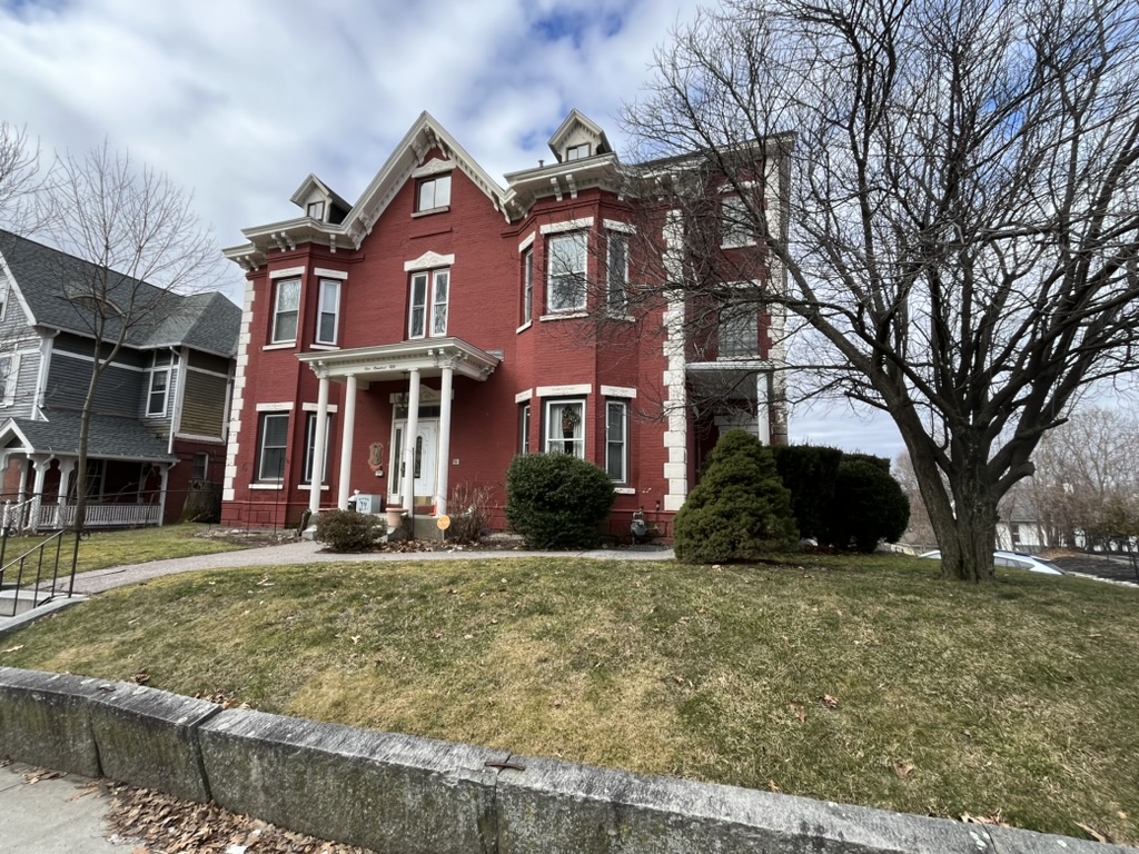
The real architectural gem in this area and the property with the deepest connection to the original road from Worcester to Boston is set back from the road on a large property behind a metal fence at 140 Lincoln Street. The Oaks (MACRIS #WOR.241), as the property listed on the National Register of Historic Places is known, is the first definitively eighteenth-century building I have encountered thus far on my walk through Worcester. The house was built for Judge Timothy Paine, “one of the most distinguished and influential men in Worcester county during the last quarter of a century preceding the Revolution,” on three hundred acres of land he purchased in 1767 along “the Great Road to Boston.”15Caleb Wall, Reminiscences, p. 79. Construction of the house was begun in 1774, but the building was not completed for years as Paine had loyalist sympathies and was obliged to defer construction of the house during the Revolution though, unlike many Loyalists, he managed both to remain in the country and to retain his property. Despite his precarious situation during the Revolution, Paine somehow maintained his important position in Worcester society right up until his death in 1793, even running for election to represent Worcester County at the first United States Congress in 1789, an election he narrowly lost to the Anti-Federalist candidate Jonathan Grout.16Moynihan, pp. 103-105. The fascinating story of this election is too complicated to discuss in this entry but effectively Paine represented the old landed hierarchy of Worcester and was supported by the wealthy landowners and financiers, while Grout represented the yeoman farmers who had made up the bulk of the support of Shay’s rebellion. A third candidate, the Shrewsbury native and Revolutionary War General Artemas Ward, was a distant third in 1789, but took the seat in 1791 when the Federalists and the wealthy landowner class united to oppose Grout. Paine, Grout, Ward, and Shays will all reappear in the next entry. His son William, also a Loyalist, was in England at the start of the Revolution and, exiled in absentia, elected to serve as a doctor in the British Army. William Paine eventually settled in Nova Scotia, but successfully petitioned to return to Massachusetts in 1787 after the ban on Loyalists was lifted and lived in Salem until 1793, when he took over the house upon the death of his father. After the death of William Paine in 1833, his son Frederick William Paine undertook a substantial expansion of the building in the Greek Revival style and resided there until his death in 1869. The house remained in the Paine family until 1914 when it was sold to the local chapter of the Daughters of the American Revolution who maintain the house as their headquarters to this day. On Triscott’s detailed 1878 map of Worcester (see below) the house and sizeable (but nowhere near 300-acre) estate, owned at the time by George Paine, is located at the top of the map between Paine Street and Lincoln Street. The property remains essentially unchanged today, flanking the west side of Lincoln Street for over 200 feet (see photo) and retaining a few of its namesake trees on more than an acre of green space in an otherwise densely-built neighborhood.
The house itself is an interesting reminder of the antiquity of a road that has, until this point, lacked tangible evidence of its age. However, an even more exciting discovery for me is the presence of a milestone embedded in the ground on the edge of the sidewalk flush against the long fence that lines the estate along Lincoln Street. This milestone, located almost exactly 46 miles from the Old State House in Boston, reads 47 miles from Boston 50 to Springfield. A quick look at my mile-by-mile map tells me that this milestone has likely been moved from its original spot, which was probably closer to the courthouse on Main Street located 46.7 miles from Boston. Andrews and Pierce report, on their map of 1795, that “the distance from Boston to the courthouse in Worcester is 47 miles.” No date is inscribed on the stone but there are other stones like this one along the route in Worcester County with similar font and carved from the same brownstone.17Interestingly, the stones in central and western Massachusetts, which are predominantly some type of brownstone, differ in material from the stones in eastern Massachusetts, which are sometimes pieces of granite and are rarely carved from brownstone. Further research on this topic is ongoing. Israel Chapin, who surveyed Springfield for a map produced in 1795, records the distance from “Boston to the Meeting House in Springfield as 961/2 measured miles,” which matches the mileage on the stone (47+50=97 miles). Based solely on the mileage inscribed on the milestone, which closely matches the distance along the old road prior to the building of turnpikes just a couple of years later, this is very likely to be a colonial era stone.

After the thrill of discovering a milestone and an eighteenth-century house along the the route, the last four hundred yards between the Paine estate and the second crossing under I-290 presents a dispiriting scene, as most of the original buildings that once lined the street leading into Lincoln Square have been replaced by a sequence of ugly modern buildings housing a health clinic, a hospital, a dentist’s office, a Chinese restaurant, and a convenience store interspersed among parking lots and empty lots. Instead, as I walk down the hill, I envision the numerous elegant mansions, larger and more ornate than even the Paine estate that are shown on Triscott’s 1878 map of Worcester, including the estates of wealthy industrialists like Horace Wyman, John Goulding, and Philip Moen (see map below). On Stebbins’s map of 1833 several houses line Lincoln Street from the Paine estate to Lincoln Square, but most of the area at the time was the property of the Lincoln family, which included two Governors of Massachusetts, Levi Lincoln, Sr. (1749-1820) and Levi Lincoln, Jr. (1782-1868), as well as William Lincoln (1802-1843), author of the History of Worcester; it is for this family that Lincoln Street and the nearby Lincoln Square are named.
Only one or two of the old houses remain today in variable states of repair. The Italianate Charles Miles house (built in 1851), directly across the street from the Paine Estate at 131 Lincoln Street (MACRIS # WOR.248) is now a law office and seems to be in good shape at least on the outside, but the much-altered Frederick Paine House from 1830 at 128 Lincoln Street (WOR.240) is in very rough shape, with bags of trash on the front stoop and and no front door. To be fair, this section of Lincoln Street has long been located adjacent to the train tracks, so that the west side of the road below what is today Crescent Street began its transformation from elegant rural estates to commercial and industrial buildings and tenement houses much earlier than the east side of the road.
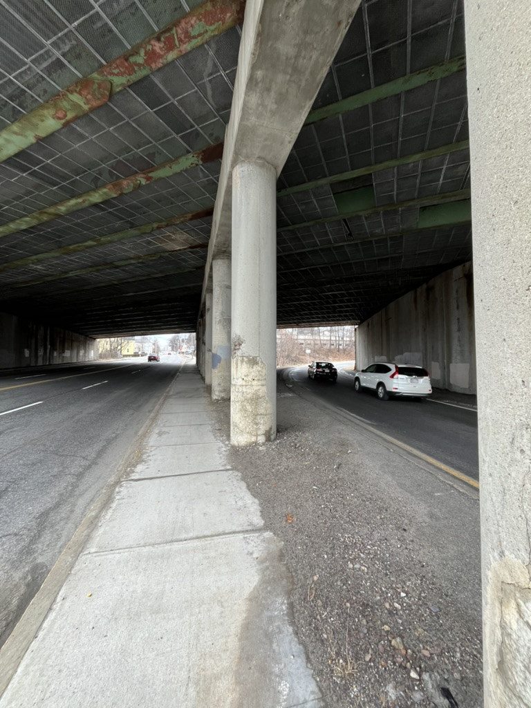
The most egregious loss in recent times along this section of Lincoln Street was the demolition of the house of another Governor of Massachusetts, John Davis (1787-1854), which stood until the 1960s on the east side of the road, at 89 Lincoln Street. Today a curved on-ramp of Interstate 290 fills the space where once the houses later owned by John Goulding and Horace Wyman were located (see the map by Samuel Triscott from 1878 below and compare with the contemporary Google map). Davis, who was born and raised on what was originally the Framingham Road but is now called Davis Street in Northborough, settled in Worcester and twice served as Governor of the Commonwealth after spending eight years in the House of Representatives as the congressman from Worcester; he also served sixteen more years as a Senator from Massachusetts. Charles Dickens spent four nights in the house during his tour of America in 1842 as did numerous other illustrious figures in the nineteenth century, when Worcester was a relatively larger and more important city than it is today, a subject I will pursue further in the following entry. It is truly a shame that so much of the character of Worcester has been erased by the desperate urge to modernize. Where once the witty conversations of some of the most interesting minds in the world could be heard drifting from the open windows of the grand houses that lined the road today is found the loud and ugly highway entrance ramp leading onto the imposing highway that crosses over the old road (see photo at the beginning of this entry). Never have the words spoken by Jesus in his Sermon on the Mount about the wide gate and the broad way leading to destruction felt more literally and figuratively appropriate.
*****
A Tangled Web

It is only is about one third of a mile from the site of the Davis mansion to the end of this walk at the old Worcester County Courthouse on Main Street, but it feels a lot longer as I am forced to weave my way through a complex tangle of very busy roads that is difficult to cross on foot. As I wait at a crosswalk to cross the exit road from I-290 onto Lincoln Street, I watch as a car speeds through a red light, hits one car, spins around and bounces off a second car, and plows into a third car about ten feet short of a school bus full of children. Amazingly, nobody seemed to be seriously hurt, but I am thankful I am on foot and hurry along to get through unscathed as the sirens of approaching emergency vehicles fill the air.
The area has always been a complicated focal point of traffic. Lincoln Street once fed into a large plaza called Lincoln Square along with seven other roads. A train line cutting through the middle of the square added more complexity to the mix, as can be seen on Triscott’s map below. The train tracks were eventually shifted a few yards east and sunk below surface level, and Lincoln Street was expanded and shifted a few yards west to accommodate the traffic flow from both I-290 and the busy Boston to Worcester turnpike (Route 9), which is called Belmont Street in Worcester and also ends in Lincoln Square.18I discussed the turnpike in the previous entry. As I approach another complex of busy merging roads I am granted a reprieve as I discover a short segment of the old road that diverges from the traffic. Old Lincoln Street is a tired, isolated, vestigial piece of the original road that once fed into Lincoln Square.
Somewhere along the west side of this section of Lincoln Street once stood a tavern operated by Luke Brown as early as 1745.19Wall, p. 57. After Brown’s death from smallpox in 1772, his son Luke operated the tavern, followed by his grandson Samuel. In Isiah Thomas’s Almanack of 1785 Brown’s tavern is located two miles beyond Knight’s tavern , mentioned above as once located at the current Hanover Group headquarters (the putative actual distance between the two taverns is about 1.7 miles), but by the 1802 version, Thomas lists the tavern as operated by (Benjamin) Butman. The tavern became known as the “Hancock Arms,” likely because of its proximity to the estate owned by Thomas Hancock (later the property of Levi Lincoln), and was a meeting place for opponents of the colonial government, in contrast to a tavern frequented by Tory sympathizers a little further down the road on Main Street operated by Brown’s brother-in-law, William Stearn, which was called the “King’s Arms,” a subject I will return to in the next entry on Worcester.
The Brown tavern was connected to an early jail building put up in 1733 “on the west side of Lincoln Street several hundred feet north of Lincoln Square.”20Wall, p. 226. A new jail was built in 1753 “a few yards south of the former one,” followed by an even larger one in 1784 on the south side of Lincoln Square itself. This last building is visible on Pierce and Andrew’s 1795 map of Worcester as well as on the 1833 map of Worcester by Stebbins (in both cases spelled “gaol house”), even though an even larger “House of Corrections” had been put up along Summer Street in 1819 (also visible on the Stebbins map). In 1824, after having been abandoned for several years, the tavern burned down.21Wall, p. 57.
Today the short (300 yards) stretch of Old Lincoln Street is more of a back alley, and most of the original buildings in the neighborhood were demolished for the redesigned road system, with the exception of three elegant brick buildings. The first building, at #34 Old Lincoln Street (MACRIS #WOR.403), is the sole survivor of a series of tenement houses built by Harrison Bliss around 1870 that can be seen on Triscott’s map (see below, adjacent to the railroad tracks at the bottom left of the map. See also the photo at the end of the entry). The larger “Bliss Building” next door, at #26 Old Lincoln Street (MACRIS # WOR.402), was put up in 1888 by the son of Harrison Bliss, William Bliss (see photo above). A third building across the street is part of a much larger complex fronting Belmont Street, originally built in 1884 and expanded in 1916 for the Morgan Construction Company (WOR.401), but today part of the campus of the Massachusetts College of Pharmacy and Health Sciences. The road then stops at a fence surrounding a parking lot for the college, so I cross back over to follow modern Lincoln Street for the final one hundred yards to the intersection with Belmont Street (Route 9) in modern Lincoln Square. Here is the meeting point of the Upper Boston Post Road, the original road from Boston to Worcester, and the Boston to Worcester turnpike, the nineteenth century road that replaced it while, a few yards away, the contemporary road into Worcester, I-290, slices through the landscape.

Curiously, although the Interstate highway has been a constant companion for most of the walk in Worcester and an intermittent one since I began this walk from Watertown, the route of the Upper Boston Post Road from this point westward does not come close to an interstate highway for nearly thirty miles, until I reach the town of Warren; It is likely not coincidental that the towns through which the road passes west of the city of Worcester are some of the least developed and least densely-populated towns I will visit. Before I can begin to contemplate walking and writing about the more tranquil towns further along the road I have four miles of walking still to describe, primarily along Main Street, until I complete my transit across Worcester along the Upper Boston Post Road. As there is still much more to discuss about the history and evolution of the road in this large and important city I have divided the rest of the walk through Worcester into two more entries.
“WALK! WALK! WALK!”…..The strident plea of the walk signal pulls me back from my reverie of meandering through the woods on the tranquil road in the towns ahead and I realize that I am still standing at a very busy intersection in the center of a big city. So I focus on the road in front of me, difficult as it is to trace in this much-changed square. Lincoln Street ends here and so I turn west and follow the route of the Upper Boston Road through Lincoln Square along Route 9, now called Highland Street, passing an elegant plaza commemorating the soldiers of the first World War on the north side of the road situated on the former estate of Stephen Salisbury, a subject I will return to in the next entry. I then cross Highland Street to reach the Worcester County Courthouse at the corner of Highland Street and Main Street, the place where this walk ends, the center of Worcester County and the place on the maps produced in 1795 for the Commonwealth from which the distances of towns in Worcester County were measured.
I wish the walk into the city had been more exciting, but it had enough points of interest to make it worth walking. Also, like the transition from winter to spring in New England, persevering through a challenging section makes the other sections that much sweeter. As I stand in front of the courthouse on a sunny late winter’s day, with temperatures pushing into the 50s and no snow to be seen, I look back across the complicated jumble of roads through which I have just emerged safely, and I breath a sigh of relief; then I turn and gaze down Main Street, which appears relatively unscathed by the effects of modern development and is lined with interesting buildings on both sides of the road, and sense that the road ahead will be very promising indeed. Although the road into Worcester was literally broad, it was a difficult road to follow. Figuratively speaking, it seems that I have actually been following the “narrow way” after all, and have managed to pass through the strait gate unto “life” or, at the very least, unto a more promising part of the walk along the Upper Boston Post Road.
*****

*****
Distance traveled in this entry along the route of the Upper Boston Post Road from the Shrewsbury/Worcester line to the Worcester County Courthouse: 3.3 miles.
Total Distance traveled along the original route of the road from the Old State House in Boston for this project: 46.9 miles.
Total Distance covered for all the walks described in Boston Rambles: 108.3 miles

