
An Essay On Post Roads, Turnpikes, And The Art Of Walking.
For Cheryl, whose journey was cut short.
*****
Why? This is the most frequent question I am asked about this project. What possible reason could I have for wandering along some old road on foot when I could much more easily and comfortably drive to all the interesting spots along the way and get to my destination much more quickly without all the bother of passing countless shopping malls and industrial parks, crossing over interstate interchanges and busy traffic intersections, sidling along the edge of roads with no sidewalks, and generally taking the long way when a shorter and faster way exists? My usual response is that I want to take the slowest route possible. Occasionally somebody gets it; mostly they slowly back away from the strange man.1I have tried to answer this question before, specifically addressing the artistic motivation; for example in my essay Main Travelled Roads. This essay is a more detailed discussion of the specific routes I have chosen to take, as well as a more detailed description of the methodology that goes into creating an entry.
I mean it sincerely however; I really do want to take the slowest route possible, mainly because I think it is also the best route possible. My thinking is that the original roads were laid down for a reason: ease of use; for walking that is, not for driving. I know on a map the oldest roads look like the product of some creation myth where a mysterious hybrid snake/elephant drunkenly trampled over a pristine landscape meandering this way and that in a tortuous manner, creating a perversely twisted road. In fact, the oldest roads, what were in the Colonial era often called Post Roads or Great Roads, were usually built upon preexisting trails created by the people who inhabited the area long before Europeans showed up, and these roads actually follow the topography of the landscape remarkably well, avoiding steep inclines where possible, crossing rivers at the narrowest or best possible spot, the logical product of people who walked long distances seasonally with all their belongings on their backs.2This is because there were no “pack” animals in pre-Columbian North America. See Jared Diamond Guns, Germs, and Steel: The Fates of Human Societies (New York: Norton, 1997), pp157-175. I am endlessly fascinated by the profound implications of such simple facts.
The need for speed, or at least the demand for shorter, more direct roads between population centers was a distinct and conscious product of public policy in the early American Republic. Prior to the Revolutionary War, infrastructure between the colonies was not a priority for either the Crown or the individual colonies. The main reason for this is that trade often went from one colony directly across the Atlantic; trade between the colonies (with the notable exception of the slave trade between New England and the Caribbean) was minimal and official government policies tended to exacerbate the paucity of inter-colony commerce. Hence the roads between the colonies were notoriously poor; many Colonial-era travel narratives, such as those by Sarah Kemble Knight, Alexander Hamilton, and even George Washington, describe in vivid detail the appalling condition of the roads between Boston and New York.
One of the first major demands made upon the lawmakers of the newly formed United States of America was for improved infrastructure in order to improve trade between the states and to improve the possibility of trading with other nations by moving goods faster from inland areas to the nearest seaport. The first manifestation of this drive to improve infrastructure was the development of numerous public/private turnpike construction projects. The developers of the turnpikes promised straighter and better-maintained roads, with more direct links between population centers, at a cost of course. The turnpikes were expensive to build, as they generally ignored topography in their quest for a direct route, and they were expensive to maintain. They also charged a fee for use and hence differed greatly from their perhaps slower but free predecessors, leading to a widespread phenomenon of avoiding the turnpikes, called “shun-piking.” Many turnpikes failed to make their money back for the investors and were often sold cheaply or given to the state governments to run after a few short years, one of the earliest examples of the boom and bust cycles that litter the pages of American history.
The advent of the railroads only a couple of decades after the turnpike construction craze was the final straw for even the most successful turnpikes as the transport of people and freight shifted to the new iron highways. Turnpikes slipped, like their older cousins the post roads, into a somnolent state for the remainder of the nineteenth century. The rise of the automobile at the dawn of the twentieth century revitalized the turnpikes, which were extensively rebuilt to accommodate the rapidly increasing demand for roads. US Route 1 for example, which starts in Maine and ends in Florida, was substantially, though not entirely, built along the preexisting route of a number of turnpikes, for example the Norfolk and Bristol Turnpike from Dedham, Massachusetts to Pawtucket, Rhode Island. These roads took on a new life in the first half of the twentieth century as tourists in their new cars wandered the main roads on day trips out of the city or long distance summer vacations.
The problem with these roads however, was precisely what made them valuable in the first place; they were a direct connection between population centers and hence they became crowded and slow, especially near the larger cities. Let’s take a look at two local and pertinent examples of turnpikes: the aforementioned Norfolk and Bristol Turnpike (Route 1) and the Worcester Turnpike, more commonly known today as Route 9. The Norfolk and Bristol Turnpike Corporation was formed in 1802 and the turnpike was opened for business in 1806, the corporation having convinced the state legislature to extend the original plans to include a direct road from Roxbury to Dedham center, before continuing in an almost direct line to Pawtucket. A law in 1876 resulted in the entire route from The Old State House in Boston through to Roxbury (not part of the turnpike but part of the old Post Road) and then continuing through Dedham to the Rhode Island border, being called Washington Street, which remains the name of the road today.
The distance from the center of Boston, using the Old State House as a convenient as well the historical starting point of the old road, to the Rhode Island State House in Providence along the lower Post Road, is 48.2 miles. Astute readers will remember that there were two older roads that could be taken to reach Providence from Boston in the Colonial era; I have chosen to use the one traveled in 1744 by Dr. Alexander Hamilton, as it is roughly contemporaneous with the narratives of the Upper Post Road by George Washington (1789) and the spies William Browne and Henry DeBerniere (1775). The distance following the turnpike between the same two points is 42.1 miles, 6 miles shorter than the Post Road, along a presumably better-graded road. As stated, a principal purpose of these roads was to permit improved transport of goods. Thus the main form of transport likely involved a horse and carriage, which traveled about the same speed as somebody walking, depending upon weight carried and other factors. Travel at walking speed, let’s say 3 miles per hour (m.p.h.), would mean a little more than 16 hours to traverse the distance along the Lower Post Road, compared to 14 hours using the Turnpike. Not a great savings, which might explain in part the ultimate failure of the turnpike as a commercial enterprise.
The situation is slightly different along the road from Boston to Worcester, the second largest city in Massachusetts and roughly equal in size to Providence. The oldest road, the Upper Post Road from Boston, is 46.0 miles in length from the Old State House in Boston along the historic road to Worcester City Hall. The Worcester Turnpike Corporation actually took control of the old road from Roxbury Crossing to Brookline Village before opening a new road in 1810 due west from Brookline to Worcester, carving through hillsides and building bridges straight over lakes and rivers, all at enormous cost. Unsurprisingly, the Turnpike Corporation managed to get the state to take control of the turnpike in 1833, four years before the arrival of the Boston and Worcester railroad line; thus it managed to limp along for the better part of twenty years as a commercial enterprise. The route was eventually made into a free road, today known as Route 9, and was substantially more direct than the post road, especially after the Mill Dam was built across the Back Bay in 1821, totaling 40.3 miles between the Old State House and Worcester City Hall, 5.7 miles shorter than the original road. The newer road cuts more directly west across Eastern Massachusetts, unlike the older road which arced north through Wayland, Sudbury, and Marlborough, before beginning its shift to the south in Worcester County, mainly to avoid the large body of water, Lake Quinsigamond which guards the eastern flank of Worcester. Route 9 is almost always three to four miles south of the Upper Post Road, and there is still two miles distance between the two roads as they each enter Worcester.
Traveling today by car along either Route 1 or Route 9, despite the fact that each has been much modified over the last century to accommodate the automobile, is a slow and frustrating experience. The time between Boston and Providence along Route 1, according to Google maps, is roughly 2 hours, an average of 21 m.p.h., not substantially faster than a bicycle. The route is busy almost continuously, passing the “AutoMile” in Norwood, as well as Gillette Stadium in Foxboro, to give two examples. The trip along Route 9 is only slightly better, taking about one and a half hours, a speed of about 26 m.p.h., mainly because the area between Westborough and Shrewsbury is lightly populated and thus speeds increase after the long slog through the malls in Natick and Framingham.
The idea of traveling by car between major cities at an average speed of 25 m.p.h. or worse, particularly if the vehicles in question were military vehicles trying to get somewhere quickly to defend the nation, was one of the factors which resulted in the development of the Interstate Highway System in the 1950s during the administration of President Dwight Eisenhower, a man whose resume included the job of Supreme Allied Commander of European Expeditionary Forces during the Second World War. That the speed at which average Americans could travel between and around cities would increase was also a consideration and the resulting impact of this newfound freedom of movement had a dramatic impact on the development of American cities, particularly newer ones like Houston, Dallas, Los Angeles, and Phoenix in the states along the Sun Belt. The speed of travel between Boston and Providence dropped to under an hour, barring traffic problems etc. (another story for another day), and the time to get from Boston to Worcester similarly dropped to less than an hour under normal circumstances, despite the fact that the distance covered in both cases was not appreciably different than that of the turnpike. Interestingly, in the case of the Boston to Providence trip, the distance on the interstate actually increases to 48.7 miles compared to 41.9 miles along the turnpike. This was a direct consequence of the successful effort to halt the construction of Interstate 95 through the so-called “Southwest Corridor” of Boston in the 1970s, which would have continued Interstate 95 (I-95) north through the Fowl Meadow nature reserve in the Blue Hills, as well as through the neighborhoods southwest of the city center, including passing only a few hundred feet behind my house in Jamaica Plain (again, a story for another day).
Both the turnpikes and the interstate highways follow much the same route and cross each other quite a few times on the respective routes between Boston and both Providence and Worcester. As I mentioned earlier, the Upper Post Road is fairly distant from the contemporary travel corridor between Boston and Worcester. The Lower Post Road is much more closely aligned with the contemporary travel corridor, a result of the relatively flat topography south of Boston compared to the hillier terrain between Boston and Worcester, which also results in the Upper Post Road having to evade more bodies of water as it snakes west of Boston. A result of the differential development of the roads leading south from Boston and the roads leading west from Boston is that the Upper Post Road is slightly more rustic than the Lower Post Road because it does not keep crisscrossing the newer roads and thus avoids much of the development that accompanies highways. The Lower Post Road is just as interesting and winds almost as much as the Upper Post Road, but it is never far from the commercial development of Route 1 and I-95; thus the towns along the old road south are for the most part more densely populated and more developed than many of the towns along the old road west. I believe this is also part of the reason the Upper Post Road has so much more nostalgic appeal than the Lower Post Road, despite the fact that the Lower Post Road has always been more highly traveled throughout it’s history.
*****
Yes, but is it ART ? A map of the evolution of the roads leading from Boston to Providence and from Boston to Worcester. Click on the the square at top right for more information and to open a larger version of the map into a new page. The red lines are the Lower and Upper Post Road (Presumably a glance at the map explains the nomenclature). The green lines indicate the turnpikes discussed in the article and the black lines indicate the interstate highways. Notice how straight the turnpike lines are relative to the Post roads and even to the interstate highway. Also notice how far the Upper Post Road (red line at top) is from the Worcester Turnpike (Route 9) and from the Massachusetts Turnpike (Interstate 90). I believe the more “tranquil” aspect of the Upper Post Road in part accounts for the higher level of nostalgia encountered in the literature on Post Roads with respect to the Upper Post Road. Also notice the large sweeping curve of the highway route (the lower black line) out of Boston, a result of successful protests against the construction of the so-called “Southwest Corridor” extension of Interstate 95 from Canton through the Boston neighborhoods of Hyde Park, Roslindale, Jamaica Plain, and Roxbury. This project was cancelled in 1972 and thus today the drive from Boston to Providence requires a detour south and west along Interstate 93. To me, the more crooked the lines the more interesting the road. Even the crooked interstate highway is interesting!
******
Which brings me back to the original point; why do it? Originally, I walked the Lower Post Road as a substitute for something that I really wanted to do but could not: I wanted to walk the old pilgrimage route across Spain to Santiago de Compostela, the Camino de Santiago, or the Way of St James in English. Unable to do that journey for various reasons, I discovered an old road near to my house and just followed it to New York. In the process I learned a great deal about the history, culture, and geography of the United States in general and of New England specifically. I also realized that the journey is often as fascinating as the destination. I later completed my original goal of walking across Spain, and returned with even more interest in walking along old roads closer to home, which led directly to the creation of this website. In the thirty or so walks I have described thus far in this project, all but two are walks along the very oldest roads in the city of Boston and immediate environs.3Altogether this is the 60th entry. Not all the entries have been about walks; a handful of essays are about soccer, there are a couple about birds, another set of essays are about demography, and a fair number of entries are about politics (blame Trump!). These are the more “rambling” essays in Boston Rambles I have covered all of the colonial roads leading into and out of Boston in these essays. Future essays will discuss the evolution of turnpikes and walks along roads developed in the nineteenth century, more compact walks in neighborhoods, and themed walks such as architectural-themed walks or walks dedicated to specific ethnic groups and their contribution to the history and cultural fabric of Boston. I also want to follow the oldest roads further out of Boston in all directions.
Books about the Post Road almost always describe the route of the Upper Post Road as the principal and most important road between Boston and New York in the Colonial era. While I disagree with that statement, It has always been my intention to walk this route as well, both to compare it to the Lower Post Road, as well as to close the loop on the map of the Post Roads from Boston to New Haven; after New Haven there is only one Post Road into New York. Thus the direction of the newest branch of this project, the walk along the Upper Post Road between Boston and New Haven, through Watertown, Worcester, Springfield, and Hartford, Connecticut. So far, I have covered the towns of Watertown, Waltham, and Weston as I make my way west of Boston. These aforementioned towns are relatively easy to access using public transportation, which allowed me to visit the towns and walk the roads numerous times in order to fully savor the unique character of each place and of the road through each town.
However, as this article has made clear, the Upper Post Road is slightly more out of the way than the Lower Post Road, ironically slightly more off the beaten track considering it is one of the original beaten tracks. When I researched and walked along the Lower Post Road I had the luxury of being able to sleep in my own bed each night until I headed south out of Providence, Rhode Island, fifty miles from my doorstep, after which it became increasingly difficult to travel back and forth each day from home. Even still, along virtually the entire route, there was almost always a train station close at hand, because the Amtrak line from Boston to New York runs along this corridor as well, or a bus that could whisk me home in a couple of hours.
As I head further west along the Upper Post Road, it becomes a little more difficult to flit into and out of a given town for the day. To get to Weston, the town furthest along the Upper Post Road about which I have written thus far, without a car is a little tricky but doable: MBTA Orange line from Green Street to North Station, Fitchburg Commuter rail line to Kendal Green station, then a one-mile walk along Church Street to reach Weston Town Green. From there the Post Road extends in both directions, allowing me to walk back and forth a couple of miles in each direction, before returning to the train station for the journey home.
Wayland, the town after Weston along the road, for example, is more complicated to visit for a day walk. There is literally no mode of public transportation that travels into the neighboring town of Wayland. Kendal Green Station is 3.1 miles from the Weston/Wayland border, which is the beginning of the Post Road walk in Wayland, about 4.4 miles in total. So a round trip from Kendal Green results in about 15 miles walking, plus about 3 hours on public transit. That leaves little time to spend in the library, visit museums, or to stop and examine artifacts along the road, not to mention birding, which I often do as I pass scenic areas.
An alternative route would utilize the western transport corridor but, as I have mentioned, the modern corridor, including public transit, sits 3-4 miles south of the Upper Post Road, making it just as difficult to access the road from the south. It is theoretically possible to get to Marlborough, to take one example, using a combination of the Worcester Commuter rail to Framingham and a bus from Framingham to Marlborough. Getting to Wayland or Sudbury, even taking buses to get as close as possible, still requires a walk ranging from three to five miles, depending on the destination.
A walk west along the Upper Post Road thus becomes an adventure from this point on, a walk not unlike the Camino in that it requires planning in order to reach a place where a bed can be found, to make sure I have enough clothing for an extended trip, that I have all the material I need for my research of multiple towns instead of just what I need for a one day visit of a single town. In short, the project has quickly become a proper trip and I have become a traveler, despite the fact that the eastern border of Wayland is exactly twelve miles from my house as the crow flies.
And in the end, that is the answer to the question postulated at the start of this essay; I can have a proper trip, a real adventure, a mere twelve miles from my house. I don’t need to go to Spain or to some exotic locale like Thailand or Peru to have a new experience. The combination of walking along old roads, searching for historical artifacts along one of the oldest roads in the entire continent, looking for birds to fill out my life lists in counties where my lists are scarce, discovering the always unique blends that make up each town along the way, from the always interesting and different ethnic makeup of each town, to the individual history of each place and its connection to the larger themes in American History; these are the ingredients required for an adventure. Driving is annoying, at least to me, and inculcates a sense that one needs to constantly move on to the next big thing, which results in a desire for straighter roads, for faster speeds, a desire to get to the destination. I don’t care about the destination, I care about the journey. I want to travel as slowly as possible; it is always the best route.
*****
The recent death of my sister Cheryl, an artist, has got me thinking about the definition and purpose of art. I never thought of myself as an artist or even as artistically inclined. However, I have been looking at the maps of my walks with a different eye lately and I realized that they look beautiful to me. The lines themselves, the patterns formed by the walks I have taken have a quality that I would venture to say flirts with artistic. The walks always stimulate my imagination. Each walk has a pattern and a unique quality that makes it different from every other walk. I try to capture the unique quality of each walk in my essays, not just thematically, but in the style in which they are written, and with photographs that try to capture the essence of the particular walk. The walks are art. This has always been a theme of this project, starting with the first essay. After all, Thoreau, who knew one or two things about walking, referred to walking as an art in an essay entitled Walking, which I used for the title of my very first essay, almost thirteen years ago.
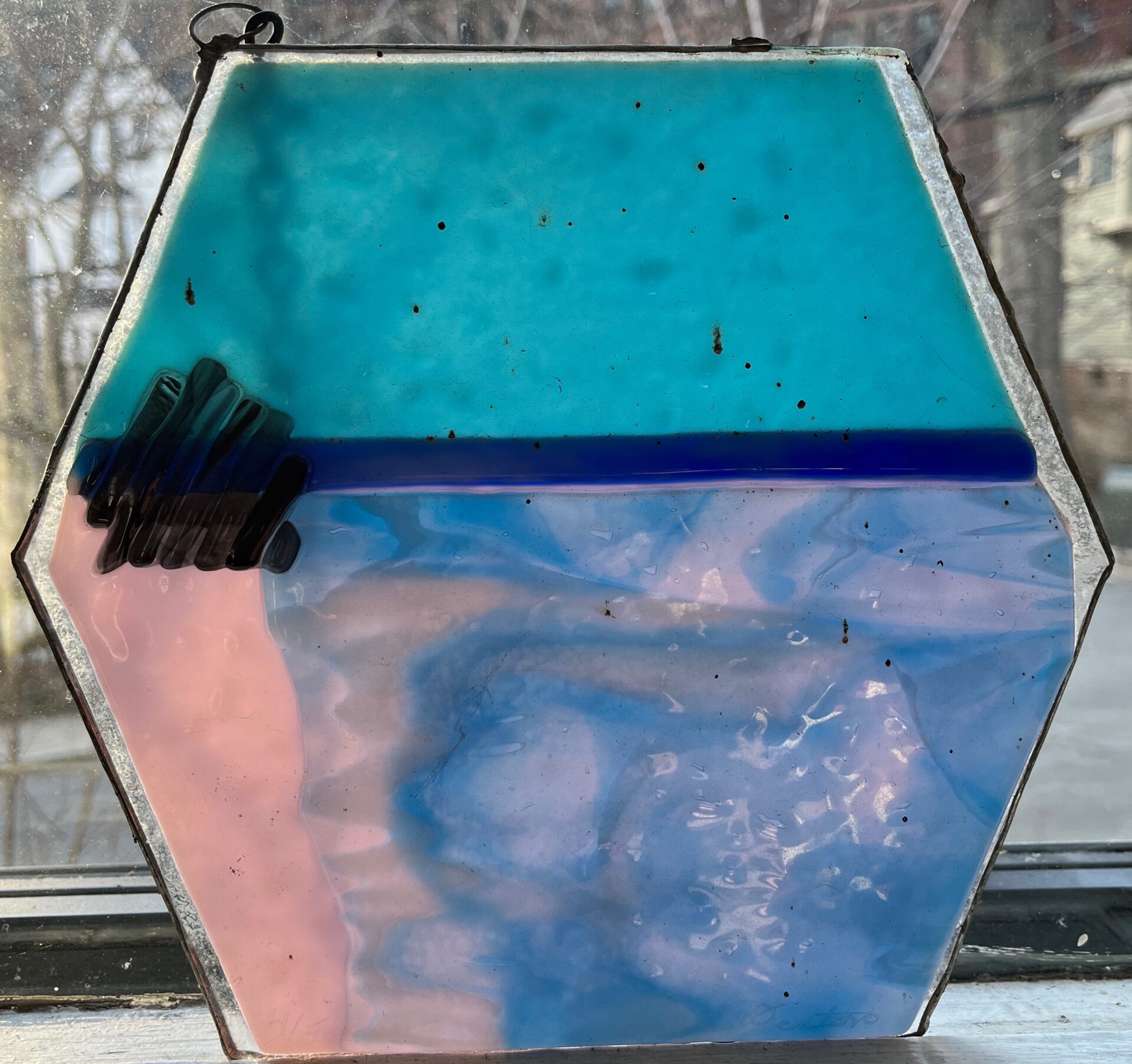
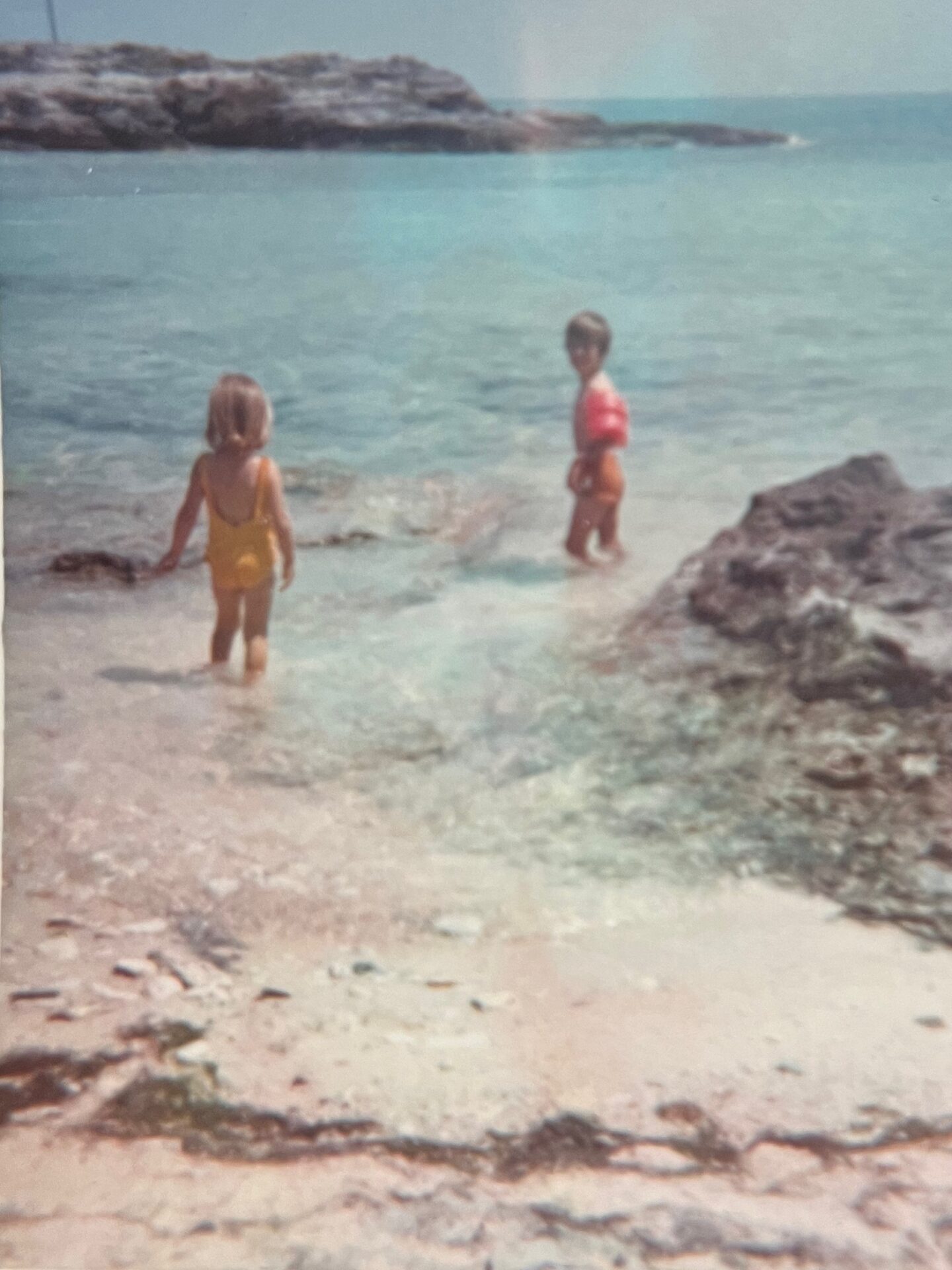
Cheryl was, next to my wife, my most dedicated reader. For many years she worked in fused glass, creating images that are enhanced by natural light. The one below was part of a show she did about Bermuda, the place we lived in as children. Anyone who has been to Horseshoe Bay, a place we spent many happy hours, can see she captures the spirit of the beach; as the light changes during the course of the day, different colors become more apparent; the pink swirls of the sand constantly change and grow brighter as the sun plays along the window in the middle of the afternoon, the deep blue waters beyond the reef get darker later in the day. This piece of art is, to me, both a universally appealing image as well as a deeply personal statement. It captures the light and color and my memory of the place better than any photograph can. My humble aspirations to art cannot hope to be even marginally as successful as her art work, but the spirit of artistic enterprise with which they are imbued is dedicated to her.
[…] discussed the development of transport corridors out from Boston in a previous entry, particularly the change from Post Roads to Turnpikes to Interstate Highways. One of the points I […]
Permalink[…] Standing in front of the old Pease tavern on Main Circle, if I take a left and pass along the west side of the house, and follow Walnut Street south, I will arrive in 1.3 miles at Route 9, called Boston Turnpike in Shrewsbury, the new road opened as the Worcester Turnpike sometime after 1806. Today it is a busy highway lined with shopping malls and commercial development as well as an increasing number of residential developments. The most prominent feature of the turnpike as it winds its way out from Boston through Brookline and on to Worcester is that it is remarkably straight. The “straight-line” distance from the original site of the Worcester Courthouse to the Massachusetts State House on Beacon Hill is 39 miles, while the distance from the Courthouse to the State House along Route 9 and its later extension in Boston across the Back Bay is 40 miles. The route from the Old State House in Boston to the Worcester Courthouse along the route of the Upper Boston Post Road is nearly 47 miles; thus the turnpike shaved almost seven miles off the trip from Boston to Worcester. Incidentally, Shrewsbury is the first town since Brookline in which the original road from Boston to Worcester and the Boston to Worcester Turnpike are physically located in the same town: as the Post road began its southwestern swing around Assabet Hill in Northborough it began to slowly close the distance between the newer road and the original road, a gap I discussed in a previous entry. […]
Permalink